
The advent of modern technologies for data acquisition is leading to data-rich industrial and environmental contexts. Not only large datasets, but most often complex types of data, such as curves, images or tensors, are routinely collected in data-driven engineering applications, posing new challenges for geo-scientists. In recent years, the Statistics group at MOX has been facing the challenge, by proposing Object-Oriented Spatial Statistics as an innovative paradigm of analysis that merges the viewpoints of spatial statistics and Object Oriented Data Analysis. At the very frontier of statistical science, O2S2 allows for the analysis of varied types of smart spatial data, ranging from data on soil composition (Figure 1), to production curves in shale reservoir (Figure 2), to tensor data representing associations between aquatic variables (Figure 3). O2S2 has already found successful application in several environmental studies dealing with data collected on the surface and in the subsurface of the Earth, such as those typically available in hydrogeological studies (e.g., Figures 1 and 3), and in the oil and gas industry (e.g., Figure 2).


Figure 2. Spatial prediction of gas production rate curves in an unconventional reservoir in USA. Data source: Drillinginfo.

Figure 3. Spatial analysis of covariance matrices between water temperature and dissolved oxygen in the Chesapeake Bay (USA). Data source: Chesapeake Bay Program.
The Statistics group at MOX is currently involved in a number of projects for environmental monitoring, with particular regard to the areas of geosciences dealing with natural hazards. For instance, O2S2 has been recently introduced as an innovative approach to the analysis, prediction and simulation of shaking fields generated from earthquakes events, in partnership with INGV (Istituto Nazionale di Geofisica e Vulcanologia). In the context of hydro-geological natural hazards, O2S2 is currently used as the statistical framework for the data analysis and uncertainty quantification in the project SMART-SED, funded by Fondazione Cariplo and aimed to the study of sediment transport in mountain regions (www.facebook.com/pg/smartsedproject). The pilot case study for the project is the Caldone Basin (near Lecco), where an extensive campaign of data collection has been held over the last years. Thanks to the advent of low-cost technologies, hundreds of pebbles were equipped with sensors, turning them in smart pebbles whose movement – consequent to precipitation events – can now be tracked. This large amount of data is being integrated with the highly heterogeneous types of data available at other data repositories (e.g., on region geology, soil composition, cover and lend use), and will be eventually used to calibrate a mathematical model of sediment transport in the basin. The SMART-SED project is based on a close partnership between the Department of Mathematics and the Department of Environmental and Civil Engineering of Politecnico di Milano. It provides a paradigmatic example of the strong interplay between different yet complementary fields of applied mathematical geosciences, which is key to the success of modern data-driven applications.
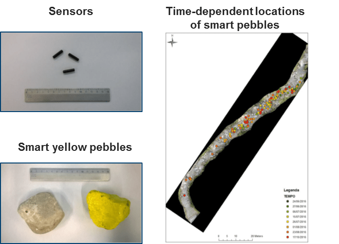
Figure 4. Smart pebbles in the SMART-SED project, for the study of sediment transport in mountain regions.